1/14


GPS on ski map
1K+下载次数
12.5MB大小
3.79(06-05-2025)最新版本
详情评价版本信息
1/14
GPS on ski map介绍
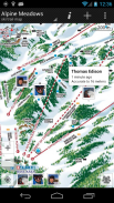
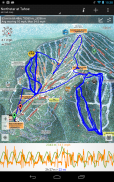
Maprika 是滑雪胜地、公园和校园的最佳测绘解决方案。
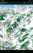
Maprika 使用 GPS 在“纸质”地图上放置“您在这里”标志,就像您在滑雪场售票窗口或公园信息亭看到的那样。
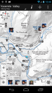
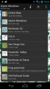
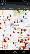
• 在 15000 多张滑雪胜地、徒步旅行和自行车道、主题公园和大学校园地图上导航
• Maprika 地图保存到手机内存中,以便在服务之外的区域使用。
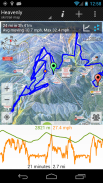
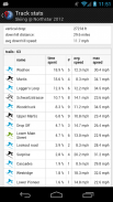
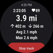
• 记录GPS轨迹并实时显示;导出曲目并在您的计算机上查看它们;在 Wear OS 设备上记录 GPS 轨迹
• 与朋友分享您的位置
• 通过在地图上指出地点来安排与朋友的会议
• 制作您自己的地图并与 Maprika 社区分享
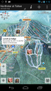
• 查看当地天气、降雪报告和 Twitter 源的度假村地图,查找附近的景点
GPS on ski map - 版本3.79
(06-05-2025)新特性- record track on android watch- get heart rate from android watch when recording track on phone, show it along the track- add an option to resume last recorded track- show track times in local time of track location
GPS on ski map - APK信息
APK版本: 3.79程序包: com.maprika名称: GPS on ski map大小: 12.5 MB下载次数: 75版本: 3.79发布日期: 2025-05-06 13:16:26最小屏幕: SMALL支持的CPU:
程序包ID: com.maprikaSHA1签名: 9E:5B:2E:BA:10:C2:A2:48:38:F2:A3:E3:4D:E2:14:E0:B2:14:F5:E1开发商 (CN): Dmitri Stukalov组织 (O): Maprika本地 (L): Unknown国家/地区 (C): US州/市 (ST): CA程序包ID: com.maprikaSHA1签名: 9E:5B:2E:BA:10:C2:A2:48:38:F2:A3:E3:4D:E2:14:E0:B2:14:F5:E1开发商 (CN): Dmitri Stukalov组织 (O): Maprika本地 (L): Unknown国家/地区 (C): US州/市 (ST): CA
GPS on ski map的最新版本
3.79
6/5/202575 下载次数12 MB 大小
其他版本
3.73
11/12/202475 下载次数11.5 MB 大小
3.47
6/2/202175 下载次数6.5 MB 大小
3.12
22/3/201375 下载次数2.5 MB 大小


Flip Diving 4.49
4.49
4.49


银河之战:深空射手4.08
4.08同类应用


English


